google.com, pub-1183232341631896, DIRECT, f08c47fec0942fa0 We Discover Canada And Beyond: 2012
My RV Cook Book, "Tinfoil Cooking" is now published on Amazon!

Check it out Amazon.ca, Amazon.com, Amazon.de, Amazon.co.uk or any other site worldwide! For a luxury coilbound version on 80# stock go to my cooking website AndersCooks.ca


30 November 2012

Cross Canada and Back, Part 39


Parc National de la Mauricie or Mauricie National Park of Canada


It's August the 10th 2011 and day 87 of our cross Canada Trip. This is one of those days you just file away in the back and hope that it never appears again.


The heavens opened up and it rained
We broke camp in pouring rain and drove from Alma over Hwy 155 to La Tuque to the La Mauricie region. After hours of driving in the rain, we arrived at Camping Marina St. Roch de Mekinac. 


View On the road from Alma to La Mauricie National Park. in a larger map

This campground was not set up very good, the sewer hook ups were located way in the back of the site..... not good and the people were  mostly seasonal  I think we were the only transient campers.


11th of August 2011, day 88

Today we prepared ourselves to go on a long hike in La Mauricie National Park of Canada. The weather looked pretty good in the morning. We packed our sandwiches, tea, water, chocolate, and bear- and bug spray. 


Anders at the entrance to La Mauricie National Park of Canada.
Our plan was to hike the Lac Solitaire Trail, approx. 6km starting from Rivière-a-la-Peche parking lot. It is an intermediate trail promising wonderful viewpoints and look-outs over lakes and diversified forests. Well, we were only walking about fifteen minutes up the steep hill, when the heavens opened up and it just poured buckets. 


Another wonderful National Park of Canada

So beautiuful
We were soaked to the bones in no time. And with the trail getting really slippery over the mud and roots, it was time to turn around. Back at the truck, we turned the heater on high, and soon we were try again. 


Liz taking in the sights

Wonderful lakes for canoeing or kayaking
We then toured the park by driving from viewpoint to viewpoint. The route through the park is about 60 km long from Saint-Jean-des Piles to Saint Mathieu. This is an absolute beautiful park for hikers, canoeists, cyclists, and motorists. Over 500 square km of idyllic lakes, forests and Precambrian pink granite.


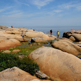
La Maurice National Park of Canada at it's best.


The park includes part of the Laurentian Mountains, which are part of the Canadian Shield formed between 950 - 1,400 million years ago. The park offers several hiking trails from easy to difficult. There are many wilderness campgrounds on the quiet lakes, some places have kitchen shelters and picnic shelters. 

Among others you could rent canoes on Lac Edouard, Le Passage Wapizagonke, and Shewenegan. Boat launching ramps are by the major stops. There are visitor interpretation centres at Saint-Mathieu and Rivière-de-la-Peche, although that one was closed when we were there. 


Canoeing anyone?

Canoe Rental
The park has many hills and valleys, serious cyclists were out in force labouring themselves along the roads. In winter this park must be a wonderland for cross country skiing.


Anders enjoying the scenery.

Blueberries.


There were signs warning us of wild animals, and to please leave them wild. There are an estimated 300 Moose in the park. La Mauricie National Park is the most easterly Canadian national park that is still home to a wolf pack. The wolf is a key species in the forest ecosystem to keep the moose population at a sustainable level. It is estimated that there are about 100 to 125 black bears in the area, some have been tagged so that the wardens can guesstimate their movements and population.

We did not see any large animals, but birds, flowers and wild berries, especially Blueberries were throughout the park.


Lunch time

Liz and Anders enjoying lunch
We stopped at many places and had our lunch at a beautiful quiet lake all by ourselves. We spent the whole day in this park and thoroughly enjoyed every minute of it. Not a hike, but a great journey.

For more pictures from this part of the trip, click on the image on the bottom of the page or go directly to the slideshow by clicking below.


La Mauricie National Park in Québec


Cheers,

Anders and Liz

Here are some shortcuts to all the blogs from our Cross Canada Trip. Just hover over the number to see where it will take you

 1,    2,    3,     4,    5,    6,    7,    8,    9,   10

11,   12,  13,  14,  15,  16,  17,  18,  19,  20

21,   22,  23,  24,  25,  26,  27,  28,  29,  29b

30,   31,  32,  33,  34,  35,  36,  37,  38,  39,

40,   41,  42,  43,  44,  45,  46,  47,  48,  49,

50,   51,  52,  53,  54,  55,  56,  57,  58,  59,

60,   61,  62,  63,  64,  65.

.

Cross Canada and Back, Part 38

Quebec at it's best


Sunday 7th of August 2011, day 84 of our Cross Canada Trip.

We woke up to heavy rain.  But Sundays are good travelling days. 


View La Malbaie to Alma and Lac Sain-Jean in a larger map

We packed up and were happy that the Malbaie River bridge was still in tact after the heavy rain over night (our only way out of the campground). 


Its raining cats and dogs

Our destination today was the Dam-en-Terre campground in Alma, close to Lac Saint-Jean.


Water fall at Chutes Fraser campground in Rivière Malbaie
From La Malbaie north we reached Saint Siméon a funky pretty city. There we left the St.Lawrence River and headed north-east on Hwy.170 toward Saguenay City, Ha Ha Baie, La Baie, Jonquière, Laroche and Alma. It would be a pretty drive, very windy and lots of up and down, but with the rain, it was ok.


A small town along the way

Wonderful landscape
Our campsite at Dam-en-Terre is nicely shaded. We are among tons of family vacationers. There are about 90 sites with lots of facilities, and it is very well run, young and old is enjoying themselves. 


Very nice campground with lots of space

Our campsite at Dam-en-Terre
Here we are in the heart of French Canada, we are the only Anglos, with a licence plate not from Québec.


Monday 8th of August 2011, day 85.

Brilliant sunshine wakes us up. We indulge in bagels and cream cheese with a great fruit salad for breakfast. 


Liz
We plan our day trip to visit Sainte-Rose-du-Nord. It is south, about half way between Alma and Tadussac on Hwy 172, on the Route du Fjord. The areas around Alma, Jonguièrea and Chicoutimi are very industrialized, Alcan and wood factories  ( operational and not) dominate the skylines. 


Forest industry is busy

Masses of wood waiting to be processed
Through  farmland, hills, and forests we arrive at the tiny village of Sainte-Rose-du-Nord on a pretty bay on the Saguenay Fjord. Tour-boats stop here. 


Here you can take a boat tour

Anders at Sainte-Rose-du-Nord
We hike to the top of the bluff above the village, and enjoy a wonderful view over the valley and the river. 


A hike is in order...

View over Sainte-Rose-du-Nord

Wonderful views from up here.

The forest and all the vegetation smells so fresh.
Later we order Poutine and Soupe Maison at the restaurant at the boat launch, we are not impressed. On the way home we visit " La Petite Heidi" on 504 Boul. Tadoussac and buy some great goat cheese from a local farm for our supper.


Tuesday 9th of August 2011, day 86.


Our plan today is to drive around Lac Saint-Jean. This is the Province of Québec's largest inhabited lake.  This lake covers about 1,000 square km, in a basin left after the last ice age.. Many small rivers feed this lake, which then becomes the source of the Saguenay River. 


Our quest for the day; drive around Lac Saint-Jean

Liz and Lac Saint-Jean in the back ground.
The route 169 ( Blueberry Route) is about 230 km around the lake through farmland, rocky, spruce-covered wilderness and quiet, charming villages.

Beautiful country side.
Already in St.Gédéon, the farms, gardens, and  the villages look better kept. Pride of ownership is very apparent everywhere. The Fromagerie and Chacuterie in St.Gédéon is a dangerous place to stop and shop. They have wonderful specialty foods, including Anders' favorite cheese curds. All along the lake one can see tons of cottages and homes on the warm sandy beaches. 


Blueberry fields


On the north side of the lake between Félicien and Péribonka we first have the impression that the land is left wild and unattended. But no, these are wild blueberry fields. The blueberries here are not on large bushes, but rather ground-covering growths. 


Harvesting Blueberries


Farmers are harvesting them with small machines looking like snow-blowers with a baleen shovels up front. Very interesting. 


Blueberry Harvest


Chocolate covered blue berries

Yum!

Very friendly people
We stop for some chocolate covered blueberries. Around the whole lake cyclists can enjoy the area on their designated " Véloroute des Bleuets".  This was a very good day.

For more pictures from this part of the trip click the bottom image or go directly to the slide show.


Riviere Malbaie,Lac Saint-Jean to La Mauricie


Cheers,

Anders and Liz

Here are some shortcuts to all the blogs from our Cross Canada Trip. Just hover over the number to see where it will take you

 1,    2,    3,     4,    5,    6,    7,    8,    9,   10

11,   12,  13,  14,  15,  16,  17,  18,  19,  20

21,   22,  23,  24,  25,  26,  27,  28,  29,  29b

30,   31,  32,  33,  34,  35,  36,  37,  38,  39,

40,   41,  42,  43,  44,  45,  46,  47,  48,  49,

50,   51,  52,  53,  54,  55,  56,  57,  58,  59,

60,   61,  62,  63,  64,  65.

.

26 November 2012

Cross Canada and Back, Part 37


Saguenay River and Beluga Whales

It is Saturday the 6th of August  2011, day 83 of our Cross Canada Trip.

Today our plan was to sight-see along Hwy 138 north, along the St.Lawrence River to Baie Sainte Catherine and Tadoussac to the mouth of the Saguenay River.


View Saguenay River and Beluga Whales in a larger map

When we arrived in St. Catherine, the whale watching expeditions were extremely busy, busloads of tourists. Not our thing. A nice young man at the Parks Canada Interpretation Centre advised us to just go on 300 meters, and to stop at the Pointe Noire National Park Site. It is just before the ferry terminal, there we might be able to see some whales. 


Saguenay River Ahead

Wonderful Country Side
Said and done, we stop at Pointe Noire National Park Site. Not five minutes passed observing the Saguenay River, when we got all exited, there was a pod of Beluga Whales swimming down along the rocks toward the St.Lawrence estuary. Wow they are just beautiful! Usually Belugas are only at home in the cold waters of the Arctic Ocean. But somehow thousands of years ago, probably after the last ice age, these Belugas stayed here, and are happily existing this far south. Amazing!


Liz and the Saguenay River in the back drop.

There are the Beluga Whales

Point Noir National Park Site
We then continued across the Saguenay River on a very efficiently run, nice and free ferry. We were so exited and hoping to see more Belugas, that we did not stop in Tatoussac. The village of Tatoussac was the first fur-trading post in Canada. 


Driving past Tatoussac, we stopped at Cap-de-Bon-Désir. Here we could venture out onto the rocks polished by the tidal waters of the St.Lawrence River. This is a beautiful spot to look out for marine life. We did not see any more whales, but some Dolphins swam by looking curious at all us people sitting on the rocks.


Cap-de-Bon-Desir


Liz overlooking the St. Lawrence River at Cap-de-Bon-Desir
Further north we stop at the Marine Environment Centre, unfortunately the underwater interactive video ( direct video contact to the underwater marine life in the estuary) was fully booked out. Make sure to call ahead and reserve a spot, looks like a lot of fun.


Beluga Whales

Beluga Whales
On the way back we stopped again at Pointe Noire where we saw the Belugas, it was a beautiful vista over the Saguenay River and the St.Lawrence River, but the Belugas were hiding. The Saguenay River flows through the world's most southerly natural fiord. This fjord was formed about 10,000 years ago by a retreating glacier ( hence the Belugas). The fiord is up to 300 meters deep and its waters look dark inky blue. The Saguenay River flows all the way from Lac Saint-Jean to the St.Lawrence estuary.

Happy, and full of new impressions we came back to our campsite at Chutes Fraser in Rivière Malbaie.

For more pictures from this part of our cross Canada trip click on the picture below or go directly to the slideshow here.
From La Malbaie to Tadoussac and back,Belugas

Cheers,

Anders and Liz

Here are some shortcuts to all the blogs from our Cross Canada Trip. Just hover over the number to see where it will take you

 1,    2,    3,     4,    5,    6,    7,    8,    9,   10

11,   12,  13,  14,  15,  16,  17,  18,  19,  20

21,   22,  23,  24,  25,  26,  27,  28,  29,  29b

30,   31,  32,  33,  34,  35,  36,  37,  38,  39,

40,   41,  42,  43,  44,  45,  46,  47,  48,  49,

50,   51,  52,  53,  54,  55,  56,  57,  58,  59,

60,   61,  62,  63,  64,  65.

.